December 11 Update: Closures Due to Flooding
December 11, 2014
Update Thursday, December 11, 8:00 am
9:00 am - added links to maps
Courtenay Flood Update
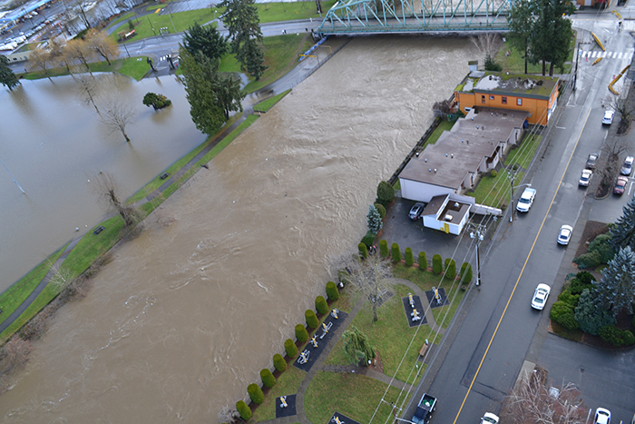
The State of Emergency continues today in the City of Courtenay, Thursday, December 11. The City will continue to monitor levels and coordinate flood response with BC Hydro and Emergency Management BC.
The evacuation order for the Puntledge Business District remains in effect until further notice.
The evacuation alert for the wider area adjacent to the Tsolum River, Puntledge River and Courtenay River (within the boundaries of the City of Courtenay) remains in effect until further notice.
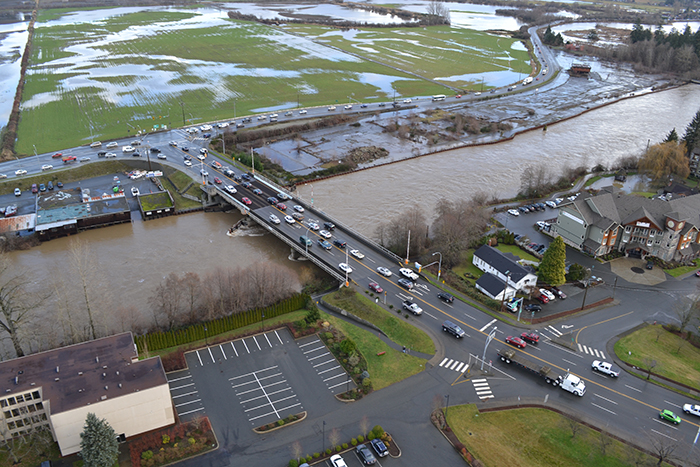
The Highway 19A bypass is open, but if conditions change, the Ministry of Transportation may close the bypass again without notice. The Highway 19A bypass is between Ryan Road and the 17th Street Bridge.
The City of Courtenay has received many kind offers of help from residents, businesses, organizations, and 19 Wing Comox. At this time, we are working with Emergency Management BC and several other agencies to deal with the State of Emergency. If at some point we determine volunteers are required, we will certainly ask. The City truly appreciates these offers of support.
Road & Intersection Closures continued from yesterday
PDF Maps:
Road Closures
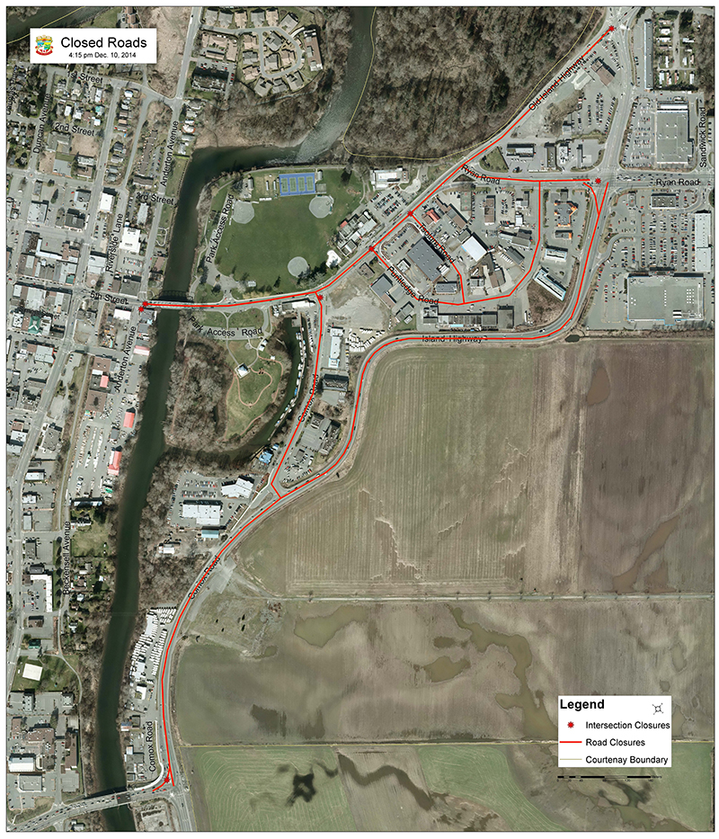
- Comox Road CLOSED from Highway 19A bypass (by Kia dealership) to Old Island Highway
- Old Island Highway from 5th Street Bridge to Headquarters Rd.
- 5th Street Bridge CLOSED
- Puntledge Road & Tsolum Road CLOSED
- Dove Creek Road between Headquarters Road and the Dove Creek Bridge CLOSED
Intersection Closures
- Old Island Highway at Headquarters Road
- Ryan Road at Highway 19A bypass
- Comox Road at Highway 19A bypass
- Anderton Road at 5th Street
- 5th Street at Anderton Avenue
Please obey traffic control signage and/or traffic control personnel. This is important for your personal safety.
Facility Closures
- The Lewis Centre is CLOSED again today and programs are cancelled.
- The LINC Youth Centre is CLOSED again today and programs are cancelled.
Trail Closures
- The Courtenay Riverway / Airpark Walkway is CLOSED
- A portion of the Rotary Riverside Trail has been CLOSED since late November due to a slope failure
Caution is recommended alongside ALL local rivers, as river levels are exceptionally high and currents are strong
We will post updates on the City website at www.courtenay.ca and on the City of Courtenay Facebook and Twitter channels as they become available.
________________________________________
Update Wednesday, December 10, 9:00 pm: The MInistry of Transportation has advised they will be reopening the Highway 19A bypass. If conditions change, this may be closed again without notice. The Highway 19A bypass is between Ryan Road and the 17th Street Bridge.
No mapping staff are available overnight; we will update the road closure map as soon as possible in the morning.
Update Wednesday, December 10, 6:15 pm: This is the most up-to-date road closure map. The flood situation and road closures in Courtenay are ongoing. Please, if you don't have to travel tonight, we are requesting that you stay off the roads to reduce the challenges for emergency responders and traffic management. Please note that Dove Creek Road at the Dove Creek Bridge is also closed and is not shown on the map below.
Click here for the closed roads map below in larger format: Closed_Roads_1615h sm.pdf [PDF - 510 KB]
Update 3:55 pm: Road closures are evolving rapidly. Check our Facebook and Twitter feeds for rapid updates:
www.facebook.com/cityofcourtenay
www.twitter.com/cityofcourtenay
Update Wednesday, December 10, 2:00 pm:
Road closure update: we need to CLOSE the following roads again due to rising water levels:
- Puntledge Road CLOSED
Update Wednesday, December 10, 12:00 noon: Update on the road closures. We have been advised by BC Hydro that we can OPEN Comox Road, Puntledge Road, and Tsolum Road. Crews are in the process of opening up these roads to allow local access. Please drive carefully around Public Works crews placing sandbags in the vicinity.
These roads may close again on short notice depending on flood levels. Thank you for your patience.
Update Wednesday, December 10, 11:50 am
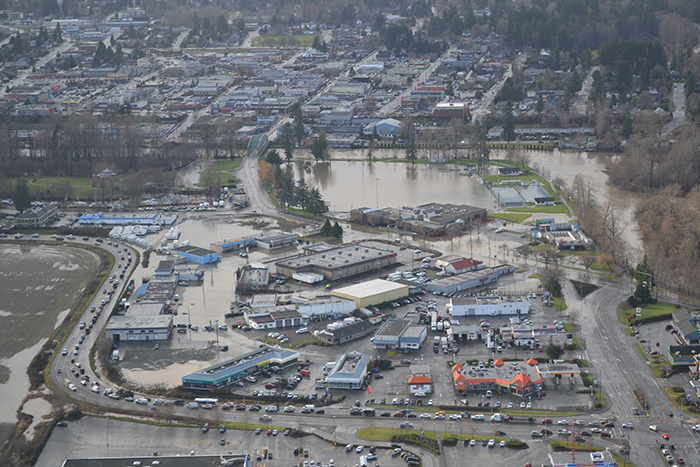
BC Hydro is releasing the maximum amount of water possible at the Comox Dam. This water flows down the Puntledge River and meets up with uncontrolled, elevated flows from the Tsolum and Browns Rivers. While river flows dropped earlier in the day, they have been increasing over the last few hours.
The City is going to be increasing and deploying the amount of sandbags in the flood zone, in particular along the Old Island Highway, between Comox Road and Headquarters Road. Crews will be mobilizing on-site.
We are receiving support from the Province of B.C and regular information updates from BC Hydro. In addition, neighbouring municipalities and private businesses have also offered their support. The City of Courtenay gratefully acknowledges these offers and is determining how and when to allocate these resources.
Residents: do you need sandbags? Sand and bags are available for residential use at the Courtenay Firehall, 650 Cumberland Road. Please bring a shovel and be prepared to fill your own bags. A coordinator will be on-site.
Businesses: any businesses in the affected area that need sandbags should call the City of Courtenay Public Works Yard at 250-338-1525.
Wednesday, December 10, 8:00 am
The State of Emergency continues today in the City of Courtenay, Wednesday, December 10, 2014.
The City will continue to monitor levels and coordinate flood response with BC Hydro and Emergency Management BC. High tide is at 8:45 am, and a storm surge and heavy rainfall are expected to further increase water levels.
The City appreciates that BC Hydro is doing everything they can to manage the water levels that are in their control.
The City would also like to thank the public for their cooperation during this flood event.
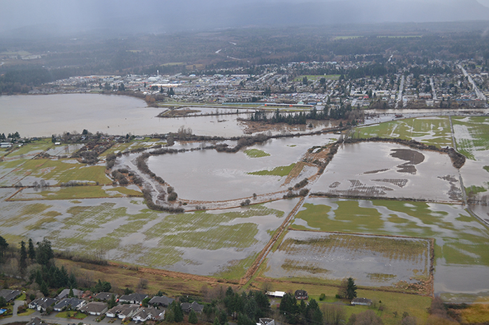
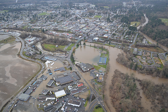
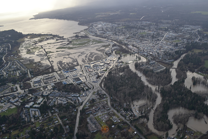
click to enlarge photo
Road & Intersection Closures
These closures continue from yesterday, as water levels remain high and tides continue to be a concern.
Road Closures
- Comox Road CLOSED from Highway 19A bypass (by Kia dealership) to Old Island Highway
- Old Island Highway from Comox Road to Headquarters Rd.
- 5th Street Bridge CLOSED
- Dove Creek Road at the Dove Creek Bridge CLOSED
- Puntledge Road & Tsolum Road CLOSED
Intersection Closures
- Old Island Highway at Headquarters Road
- Ryan Road at Highway 19A bypass
- Comox Road at Highway 19A bypass
- Anderton Road at 5th Street
- 5th Street at Cliffe Avenue
Please obey traffic control signage and/or traffic control personnel.
Facility Closures
- The Lewis Centre is CLOSED again today and programs are cancelled.
- The LINC Youth Centre is CLOSED again today and programs are cancelled.
Trail Closures
- The Courtenay Riverway / Airpark Walkway is CLOSED
- A portion of the Rotary Riverside Trail has been CLOSED since late November due to a slope failure
Caution is recommended alongside ALL local rivers, as river levels are exceptionally high and currents are strong
We will post updates on the City website at www.courtenay.ca and on the City of Courtenay Facebook and Twitter channels as they become available.
________________________________________
Previously:
December 9 4:00 pm - Courtenay Flood Update
A State of Emergency was declared in the City of Courtenay today (Tuesday, December 9) and will continue due to flooding and the ongoing adverse weather and high tides.
Emergency Management BC and BC Hydro advise that the risk of flooding will continue through Thursday, December 11. The City of Courtenay is working closely with these agencies as we deal with the impacts of flooding.
They have advised that we are dealing with a major flood event, potentially eclipsing the floods that occurred here in 2009 and 2010.
There are closures due to flooding in some low-lying areas of Courtenay. At this time, the following are closed:
Roads
These roads will remain closed overnight, as the water levels remain high and tides continue to be a concern.
- Comox Road CLOSED from Highway 19A bypass (by Kia dealership) to Headquarters Rd.
- 5th Street Bridge CLOSED
- Dove Creek Road at the Dove Creek Bridge CLOSED
- Puntledge Road & Tsolum Road CLOSED
Please obey traffic control signage and/or traffic control personnel.
Facilities
- The Lewis Centre is CLOSED and will remain closed on Wednesday, December 10
- The LINC Youth Centre is CLOSED and will remain closed on Wednesday, December 10
Trails
- The Courtenay Riverway / Airpark Walkway is CLOSED
- The Rotary Riverside Trail has been CLOSED since late November due to a slope failure
We will post updates on the City website at www.courtenay.ca and on the City of Courtenay Facebook and Twitter channels as they become available.
________________________________________
Update December 9, 11:55 am:
There are closures due to flooding in some low-lying areas of Courtenay. At this time, the following are closed:
Roads
- Comox Road CLOSED from Highway 19A bypass (by Kia dealership) to Headquarters Rd.
- 5th Street Bridge CLOSED
- Dove Creek Road is CLOSED at the Dove Creek Bridge
- Puntledge Road is CLOSED
Facilities
- The Lewis Centre is CLOSED temporarily (parking lot is flooded)
- The LINC Youth Centre is CLOSED
Trails
- The Courtenay Riverway / Airpark Walkway is CLOSED
We will post updates here and on the City of Courtenay Facebook and Twitter channels.