South Courtenay Riverway Extension FAQs
Questions
- What is the South Courtenay Riverway Extension project?
- Where will the South Courtenay Riverway Extension be built?
- What will the trail look like?
- What is the plan for constructing this project?
- When will construction start?
- How will the public be updated about the trail design and construction?
- Where will the nearest access points to the new trail section be located?
- How will the environment be considered during trail construction?
- What approvals are required for this project?
- How much will this project cost?
- How close will the trail be to adjacent houses?
- Will there be fencing along either side of the trail?
- Who will maintain the property?
- Will the City property be landscaped?
- Will trees be removed for the trail construction?
- Will adjacent neighbours be able to water or landscape the foreshore sections of their properties?
- Has any adjacent owner been granted a licence of occupation or encroachment agreement for the private use of public lands along the trail?
Answers
-
What is the South Courtenay Riverway Extension project?
The Courtenay Riverway is one of the Comox Valley’s most popular and scenic attractions. It is an important recreational connection, encouraging physical activity, active transportation, and well-being for residents and visitors alike. The existing Riverway Trail extends from 6th street to Millard Road and is approximately 4 km long, depending on the route taken. The north-south route on the Airpark riverfront is 4.2 km long. The inland route behind the Airpark is slightly shorter, at 3.7 km.
Courtenay Mayor and Council have directed staff to extend the Courtenay Riverway Trail further south, with an eventual goal of connecting to the Royston Seaside Trail.
The Official Community Plan, Parks and Recreation Master Plan, Transportation Master Plan and Cycling Network Plan, and the Comox Valley Regional Growth Strategy either directly identify the City’s intent to connect this valuable asset to the regional trail, and/or highlight the importance of improving connections for pedestrians and cyclists.
-
Where will the South Courtenay Riverway Extension be built?
The Courtenay Riverway Trail Extension will be built on City-owned property between Millard and Beachwood Roads. Many years ago this land was used as a railway corridor. The majority of the Courtenay Riverway Trail rests on this historic rail property, which was used by the Comox Logging and Railway Company.
Property width: 50 feet / 15.25 metres
Property length: 1,300 feet / 400 metres
-
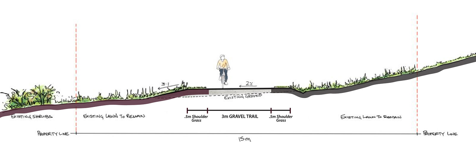
What will the trail look like?
View detailed design - July 2020 [PDF - 7 MB]
The trail will be a three-meter wide gravel trail consistent with other existing sections of the trail. The objectives are to build a safe and accessible trail, minimize disturbance to existing drainage channels and vegetation, maintain views and access across the trail for private property owners, and facilitate drainage.
-
What is the plan for constructing this project?
Phase 1, from Millard Road to Beachwood Road, will be constructed in the fall of 2020.
Phase 2, planned between Beachwood Road and Marriott Road, is approximately 350 meters long, continuing along the City-owned historic rail corridor to a City-owned, undeveloped 1.4 acre waterfront park space. Phase 2 will not be constructed until an exit is acquired at Marriott Road.
Phase 3 would connect Marriott Road to the regional trail at Chinook Road. This phase is undetermined and will not proceed until a route is established. The City does not hold title to any land in this section.
-
When will construction start?
Construction on Phase 1, the trail section between Millard and Beachwood Roads will be completed in 2020. The Riverway Trail will be entering a construction phase starting in late September. The work will begin with some tree removals and progressing into trail construction. The construction may extend into November subject to weather and any obstacles encountered.
Please stay clear of the construction site for your safety.
Estimated construction timelines for future project phases have not been determined.
-
How will the public be updated about the trail design and construction?
Updates will be posted to the project webpage at www.courtenay.ca/riverwayextension
Please follow City of Courtenay social media channels for updates.
-
Where will the nearest access points to the new trail section be located?
Phase 1 of the trail extension may be accessed via Millard Road or Beachwood Road once complete. The full Courtenay Riverway contains many access points. To view Courtenay’s entire trail network, please visit our Interactive Parks Map.
-
How will the environment be considered during trail construction?
Environmental consultants are involved in project planning to ensure every effort is made to protect the environment during trail construction. The City-owned rail corridor is set back from the sensitive ecosystems of the foreshore. Protecting vegetation along the coastal riparian zone helps protect existing natural ecosystems and prevents erosion.
-
What approvals are required for this project?
In addition to securing formal approval through the City’s 2020 budget process, the project team is obtaining all necessary permits, including Archaeological and Environmental permits.
-
How much will this project cost?
The project budget is estimated at $300,000.
-
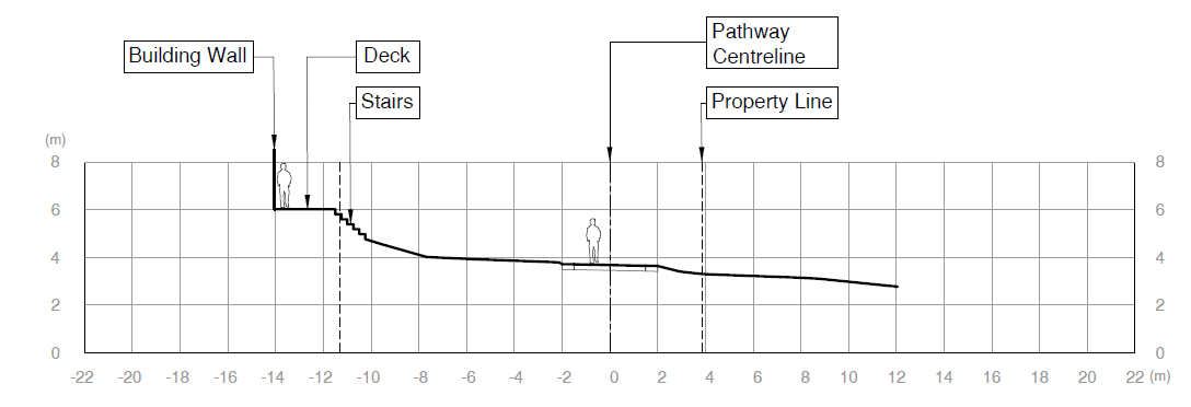
How close will the trail be to adjacent houses?
The distance between the trail and adjacent houses will vary depending on the proximity of the houses to the property line, as well as the trail route. The following sample cross-section illustrates the proximity of the planned trail to the home closest to the property line.
-
Will there be fencing along either side of the trail?
The City of Courtenay consulted with neighbors and found that opinions varied substantially on fencing. While City does not intend to fence the property at this time, a low rail will be installed to mark the boundaries of the corridor, and neighbouring property owners have been offered "private property" signage. Property owners have the right to install fencing for their own needs on their private property adjacent to the trail, on either side of the City-owned corridor, as long as the fence meets the requirements under the City’s Zoning Regulations.
-
Who will maintain the property?
The City of Courtenay will maintain the property, however there are unique considerations at this site. Neighbouring properties are divided into two sections: the main property, plus a strip along the foreshore, at the waterfront. These property owners would need to cross the trail to access both parts of their property, which falls on either side of City property. Neighbours and trail users will need to be accommodating to the others’ needs along this corridor.
Any private landscaping on City-owned land will be subject to the City’s needs and may be removed as part of trail construction. See below for more information.
-
Will the City property be landscaped?
The City-owned trail corridor will include the three-metre wide gravel trail consistent with other existing sections of the trail, plus a buffer of varying sizes depending on the terrain. Other landscaping will include grass and existing mature trees along the corridor.
Landscaping on City property will be based on the needs of the community. This means existing landscaping installed by adjacent property owners is in the public domain and may be removed at any time subject to the City’s needs. This is similar to the City lands in front of many homes throughout the City.
Property owners were advised in October 2019 to remove any landscaping or other encroachments on the City corridor that they wished to keep.
-
Will trees be removed for the trail construction?
The trail route has been shaped to maintain as many mature trees as possible along the City-owned corridor, however some trees will be removed either for trail alignment or following a diligent evaluation of tree condition for public safety reasons.
-
Will adjacent neighbours be able to water or landscape the foreshore sections of their properties?
There are strict federal regulations around the protection of coastal areas. The foreshore is an important riparian zone that must be respected. Any alteration requires federal approval through the consultation of a Qualified Environmental Professional (QEP). This area also has significant archaeological concerns.
The City of Courtenay is working with archaeologists, environmental consultants, and landscape architects, and obtaining all necessary provincial and federal approvals for the trail construction project.
Property owners are strongly advised to seek advice from independent environmental consultants and archaeologists and obtain all necessary approvals prior to performing any alterations of their foreshore property, including landscaping.
The City will not be approving the installation of private water services across City lands.
-
Has any adjacent owner been granted a licence of occupation or encroachment agreement for the private use of public lands along the trail?
No, there are no encroachment agreements or licences granted along this section of trail. These public lands are for public use.