
The Flood Management Plan is a master plan to reduce the risk of coastal and river flooding in Courtenay. It includes 86 recommended actions designed to minimize the impact of future floods.
City Council recently adopted the plan and staff are now working on implementing its recommendations.
Recommendations
Full report and related documents
- Executive summary - Flood Management Plan [PDF/4.6MB]
- Flood Management Plan - Final report [PDF/39.1MB]
- Appendix A - Historic flood events [PDF/896KB]
- Appendix B - Methodology details [PDF/2.5MB]
- Appendix C - Hazard and consequence map atlas [PDF/48.3MB]
- Appendix D - Public communications material [PDF/2.7MB]
- Appendix E - Public survey results [PDF/1.4MB]
Project background
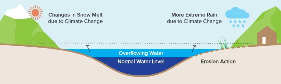
Courtenay faces flood risk along its shoreline and river systems. These risks are increasing due to rising sea levels and more intense rainfall events, which increase water levels in rivers.
This Flood Management Plan addresses these challenges with short- and long-term solutions. It considers trade-offs in reducing flood risks and is informed by:
- Courtenay’s Official Community Plan (OCP)
- CVRD’s Coastal Flood Mapping Project
- CVRD’s Coastal Flood Adaptation Strategy
- Previous flood-related projects
Image
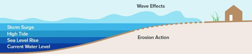
Future sea level rise and its impacts on water levels next to the sea.
Image
Learn more
- Public information session recording - June 15, 2023
- Flood risk and resilience 101 [PDF/1.5MB]
- Ways to take action
Related reading
Local resources
- City of Courtenay OCP – 2022 update
- CVRD Flood Adaptation Strategy (see glossary on page 98)
- CVRD coastal flood mapping project